NewEnglandSkiHistory.com SkiNewEngland.net
Connecticut
Maine
Massachusetts
New Hampshire
Rhode Island
Vermont
New Hampshire Cancelled Ski Areas
Mt. Jefferson
Thompson and Meserve's Purchase, New Hampshire
Proposed in the 1960s
Mt. Jefferson location map Overview
Located in the President Range, Mt. Jefferson is the third highest peak in New England at 5,712 feet in elevation. Though once surveyed for a cog railroad installation on the Ridge of Caps, the peak remains undeveloped.

Prior to the construction of Bretton Woods, Mt. Jefferson was rumored to be considered for a massive alpine ski development. Though specifics are unknown, the area could have included significant above treeline terrain, as well as a vertical drop in excess of 3,000 feet.

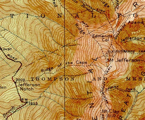
1938 USGS Topographic Map of Mt. Jefferson


Today
There are no known remains of the Mt. Jefferson proposal.

Resources
  • Mt. Jefferson - FranklinSites.com Hiking Guide
  • Mount Jefferson - Wikipedia


  • Last updated: December 11, 2012
    Also on NewEnglandSkiHistory.com...
    A monorail served ski area?
    A monorail served ski area?
    From top to bottom - American Skiing Company
    From top to bottom - American Skiing Company
    The only Skimobile in New England history
    The only Skimobile in New England history
    A ski area built on Massachusetts' highest peak that never opened...
    A ski area built on Massachusetts' highest peak that never opened...
    Beer man and owner of one of the largest ski area chains in history
    Beer man and owner of one of the largest ski area chains in history
    An area partially constructed near Manchester, NH?
    An area partially constructed near Manchester, NH?
    Topics       Links       What's New       Feedback
    NewEnglandSkiHistory.com Copyright 2002-2023, All Rights Reserved. SkiNewEngland.net