NewEnglandSkiHistory.com
CT
|
MA
|
ME
|
NH
|
RI
|
VT
SkiNewEngland.net
 
Massachusetts Cancelled Ski Areas
Hiawatha Ski Area
Blackstone, Massachusetts
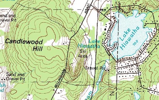
1982 USGS topographic map of Hiawatha Ski Area
Overview
Located on the eastern slope of Candlewood Hill, a ski area referred to as Hiawatha was at some point partially constructed. Displayed on the 1982 USGS topographic map, trails were cleared. It is unknown if any other facilities were constructed, or why the development was cancelled.

Today
The trails cleared for the Hiawatha Ski Area are still visible.
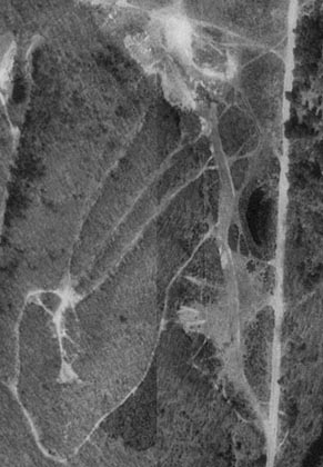
1995 USGS Aerial Photo of Hiawatha Ski Area


Resources
  • Hiawatha - New England Lost Ski Areas Project


  • Last updated: November 20, 2012
    Also on NewEnglandSkiHistory.com...
    The Hermitage Club at Haystack Mountain?
    The Hermitage Club at Haystack Mountain?
    From Thunder Mountain to Berkshire East
    From Thunder Mountain to Berkshire East
    Taking the New England ski industry by storm - fan guns
    Taking the New England ski industry by storm - fan guns
    Once one of the busiest areas in New England...now idle
    Once one of the busiest areas in New England...now idle
    Berkshire Snow Basin, Swift River, and the Ninja Turtles
    Berkshire Snow Basin, Swift River, and the Ninja Turtles
    The Puzzle of Evergreen Valley
    The Puzzle of Evergreen Valley
       CCC Trails    Cancelled Ski Areas    Expansions    Lifts    Management    Maps    News    Then and Now    Timelines    Topics    In The Press    Links    Site Map    What's New    Feedback

    Copyright 2002-2023, All Rights Reserved.