Dalton Mountain
Dalton, New Hampshire
| Overview |
 Located on Dalton Mountain, Forest Lake State Park's ski development was constructed by the CCC in 1935. Though the state park is still open, alpine skiing is no longer advertised as an activity. Located on Dalton Mountain, Forest Lake State Park's ski development was constructed by the CCC in 1935. Though the state park is still open, alpine skiing is no longer advertised as an activity.
| |
| Trails on Dalton Mountain |
 Davison Trail -
It is unknown if this trail on the northeast side of Dalton Mountain was cut by the CCC. The current status of this ski trail is unknown.
Forest Lake Trail -
The Forest Lake Trail was developed for skiing by the CCC in 1935. In addition to the trail, buildings and slopes were also constructed. The current status of this ski trail is unknown.
| |
| Quotes |
| " |
Forest Lake Trail.
Four mi. S. of Whitefield on H. 116, take road N.W., marked "Forest Lake" 2 mi., to parking area by bath house. Then follow trail markers to Dalton Mt. Here short trails offer wide choice for all grades of skiers; also open slopes for practice. 2 A. M. C. shelters on slopes are provided with firewood. By arrangement with Ernest Plant, caretaker for the Forestry and Recreation Dept. (farmhouse on entrance road) the public room with fireplace and kitchen will be opened for groups during the winter months.
|
" |
|
Skiing New Hampshire, 1935-1936
| |
| " |
Forest Lake Trail. Four m. S. of Whitefield on State 116, take road N.W., marked 'Forest Lake,' 2 m., to parking area by bath-house. Then follow trail markers to Dalton Mt. Here short trails offer wide choice for all grades of skiers; also open slopes for practice. Two A.M.C. shelters on slopes are provided with firewood. By arrangement with Ernest Plant, caretaker for Forestry and Recreation Dept. (farm house on entrance road), the public room with fireplace and kitchen will be opened for grounds during the winter months.
Davison Trail N.E. side of Dalton Mt. Range on Capt. Morris Road about 2 m. from Whitefield Village. Length 1.25 m. Max grade 25º
|
" |
|
New Hampshire: A Guide to the Granite State, 1938, p. 527
| |
| " |
[The CCC] constructed buildings, carving out trails and even building two warming log huts and outdoor fireplace to service a ski area that extended from the top of Dalton Mt. to the shores of Forest Lake.
|
" |
|
Coos County Democrat, 2009
| |
| |
| Images |
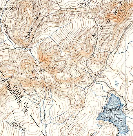
1938 USGS Topographic Map
| |
| Resources |
Forest Lake State Park - New Hampshire Division of Parks and Recreation
New Hampshire: A Guide to the Granite State. Boston, MA: The Riverside Press, 1938.
New Hampshire Skiing. Concord, NH: State Planning and Development Commission, 1935.
Last updated: June 10, 2010
| |
|